ATLANTA — The National Weather Service has issued a Winter Storm Warning for the heart of metro Atlanta, effective early Saturday morning through Sunday.
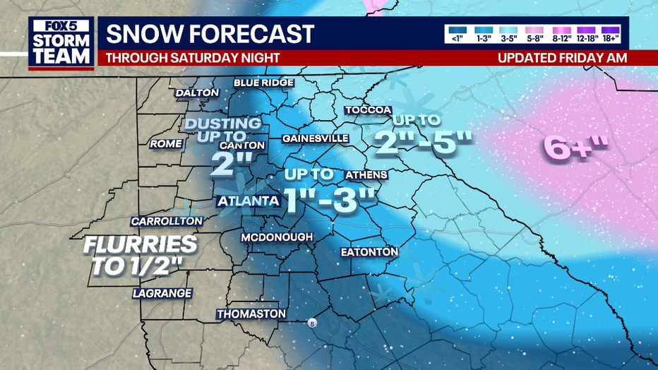
Snow totals in the hardest-hit areas (shown in pink) could exceed 5 inches. Forecasters expect 3 to 5 inches in the Gainesville and Athens areas, 1 to 3 inches across Blue Ridge, Canton, and much of metro Atlanta, and a dusting to 2 inches around Rome, Carrollton, and LaGrange.
This system is expected to produce dry, powdery snow rather than wet or slushy conditions. While that type of snow is generally less slick on roadways, strong winds will be a major concern, with gusts reducing visibility across the region.

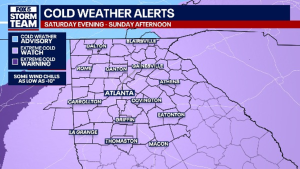
According to the FOX 5 Atlanta Storm Team, Friday will remain relatively mild with temperatures near 50 degrees, but a late-night cold front will bring heavy snow and dangerously cold air. Wind chills could drop to -10 degrees by Sunday morning.
“We’re not talking about ice this time — we’re talking about snow, and for some of you, quite a bit of it,” said FOX 5 meteorologist Joanne Feldman on Friday.
Travel conditions are expected to deteriorate quickly once snowfall begins. Meteorologists warn that snow will adhere rapidly to road surfaces, and combined with wind gusts up to 30 mph, blowing snow could significantly limit visibility.
Meteorologists continue to closely monitor the storm’s track, noting that final snowfall totals will depend on how far south the cold air penetrates. Residents are urged to prepare now and be ready for a storm alert day on Saturday.